
Basic Facts

Meghalaya "the abode of clouds", became a full-fledged State on January 21, 1972. It is bounded on the north by Goalpara, Kamrup, Nagoan and Karbi Anglong districts of Assam State, and on the east by the Districts of Cachar and North Cachar Hills, also of the State of Assam. On the south and west is Bangladesh. Meghalaya lies between 20.1 ‘N and 26.5 latitude and 85.49 ‘E and 92.52 "E longitude.
Area
Carved from the erstwhile State of Assam, Meghalaya became a fully-fledged State on January 21, 1972. Bounded on the North and East by Assam and on the South and West by Bangladesh, Meghalaya is spread over an area of 22, 429 Sq.Km. and lies between 20.10N and 26.50 latitude and 85.490E and 92.520E longitude.
Population
According to the 2011 census, Meghalaya has a population of 29,66,889 of which 1475057 are females and 1491832 are males.
Administration/Number of Districts
The State has a unicameral legislature. The Meghalaya Legislative Assembly consists of 60 elected members. There are three Autonomous District Councils, the Khasi Hills Autonomous District Council, the Garo Hills Autonomous District Council and the Jaintia Hills Autonomous District Council, which discharge functions and duties as assigned under the provisions of the Sixth Schedule of the Constitution of India.
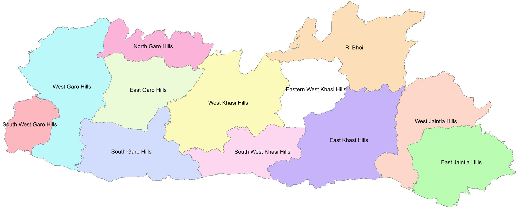
In order to accelerate the pace of development and to bring the administration closer to the people, the State has been reorganized into twelve administrative Districts, namely East and West Jaintia Hills Districts; East, West, South West and Eastern West Khasi Hills Districts, Ri Bhoi District and North, South, East, West and South West Garo Hills Districts.
Principal Languages
The principal languages in Meghalaya are Khasi, Pnar and Garo with English as the official language of the State. It was at the initiative of the Christian missionaries that the Khasi, Pnar and Garo languages and literature have developed and emerged in the list of Modern India Languages. The Khasi language spoken by the Khasis and Jaintias is believed to be one of the few surviving dialects of the Mon-khmer family of languages in India, today.
History
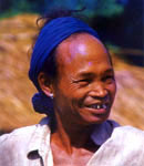
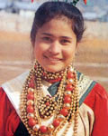
The Khasis of the Mon-Khmer group, the Jaintias who migrated from South East Asia and the Garos of the Bodo family of the Tibeto-Burma stock are the predominant inhabitants of the State. Dance, music and sports reflect their way of life. Festive sounds of merry making echo from hill to hill revealing the pulsating life of the tribal people. Mindful of their cultural heritage, these simple folks are jovial and hospitable.
The people of Meghalaya are not of the same ethnic origin. The Khasis and Jaintias are believed to be remnants of the first Mongolian overflowing into India. They established themselves in their present homeland in the remote past and, owing primarily to their geographical isolation, succeeded in maintaining their independence until the consolidation of the British administration in this part of India.
The Garo hill is the homeland of the Garos who prefer to call themselves “Achik”. Legend has is that the Garos originally inhabited a province of Tibet named Toura and left Tibet for some reason in the distant past under the leadership of the legendary Jappa-Jalimpa and Sukpa-Bongepa. They wandered in the Brahmaputra valley at the site of the present valley for centuries in search of a permanent home. In the process they survived the ordeals of wars and persecutions at the hands of the kings ruling the valley. They often branched out into a number of sub-tribes and the main group under the legendary leader, Along Noga, occupied Nokrek, the highest peak in Garo Hills.
Linguistically, Garo is akin to Bodo or kachari, which belongs to the Tibeto-Burman family languages. Life in the hills is hard, but these sturdy people are fond of dances, songs, sports and festivals.
Meghalaya with rolling hills, breathtaking waterfalls, silent lakes and a wide array of flora and fauna also has a unique blend of cultures, lifestyles, sports, dances and festivals of indigenous people comprising of the Khasis, Jaintias and the Garos.
Geography/Physiology
The Khasi Hills and Jaintia Hills which forms the central and eastern part of Meghalaya is an imposing plateau with rolling grasslands, hills and river valleys. The southern face of the plateau is marked by deep gorges and abrupt slopes. Waterfalls rush down steep slopes and carve deep valleys through which swift flowing rivers descend to the plains. At the foot of these slopes, a narrow strip of plain land runs along the international border with Bangladesh.
The northern section of the plateau has an undulating topography with a series of hills rising to almost the same height, extending northwards to slope gradually merging with the plains of Assam. The accordant summit of these hills varies from 170m to 820m. Nongpoh village lying halfway on the Guwahati-Shillong road stands on a flat top of 70m high on this hill section.
The height of the central plateau of the Khasi Hills hovers around 1500m with Shillong Peak (1965m), the highest point in the plateau overlooking Shillong town.
Garo Hills which forms the western part of Meghalaya is lower in elevation. The greater part of Garo Hills range in height from 450m to 600m and drop steeply to the Brahmaputra valley on the north and to the plains of Bangladesh on the south. Nokrek Peak (1412m), east of Tura town is the highest peak in western Meghalaya.
Climate
The State enjoys a temperate climate. It is directly influenced by the south-west monsoon and the northeast winter winds. The four seasons of Meghalaya are – Spring –March and April, Summer (Monsoon) – May to September, Autumn – October and November and Winter - December to February.
The Monsoon usually starts by the third week of May and continues right to the end of September and sometimes well into the middle of October. The maximum rainfall occurs over the southern slopes of the Khasi Hills, i.e over the Sohra and Mawsynram platforms, which receives the heaviest rainfall in the world. The average rainfall in the State is 12,000 mm.
AGRICULTURE
The Department of Agriculture, Meghalaya has been functioning as an integrated entity comprising the various spheres of development in Agriculture, Horticulture and Minor Irrigation. The mandate of the department is to bring about increased crop production and productivity. The Vision is mainly to promote holistic, sustained and equitable intervention for attaining food security; conservation, management, protection and sustainable use of natural resources for improved livelihood; generating gainful rural employment opportunities to alleviate poverty and striving towards an overall balanced economic development of the farming community while the Mission consist of propagating modern agricultural production techniques and scientific methods of farming for increasing crop output; making our farmers self reliant and to accelerate the economic growth of the State.
Agriculture forms the core of Meghalaya’s economy, contributing approximately 22% to the GDP, with 81% of the population directly or indirectly engaged in the sector for their livelihoods. Agriculture plays a pivotal role in the state's overall socio-economic development.
Rice is the major staple food in the state, occupying almost 66% of the cultivated areas, followed by maize. Millets form an integral part of subsistence agriculture in the Himalayan region, predominated by small farmers, consisting of Finger Millet (Ragi), Foxtail Millet, Pearl Millet, Job’s Tears, which are potentially grown in Meghalaya. The area under pulses such as Pea, Cowpea, Lentil, Gram, and Tur (Arhar) has gained in terms of proportions to the total sown area. The important oilseeds grown include castor, sesame, rapeseed and mustard, linseed, and soybean. Nearly 96% of the area under oilseed cultivation comes from Garo Hills, which includes fiber crops like cotton, jute, and mesta.
The state also has the maximum area under pineapple cultivation (12.6 thousand Ha), followed by Citrus (13.9 thousand Ha) and banana cultivation (7.7 thousand Ha). Meghalaya has the second largest acreage under potato cultivation (19.5 thousand Ha), next to Assam only. A consignment of l tonne of GI-tagged Khasi Mandarin oranges from Meghalaya was successfully exported to Dubai, facilitated by the collaborative efforts of the Union Ministry of Commerce and Industry and the Meghalaya Department of Agriculture and Farmers' Welfare. Building on this achievement, the Department of Agriculture and Farmer's Welfare, Government of Meghalaya, has recently established market linkages for over 1.3 tonnes of pineapples to the Middle East.
Among vegetables, Meghalaya also has a sizeable area under cabbage, cauliflower, and radish cultivation, which are mostly marketed outside the state. As far as spices are concerned, Meghalaya is the leading state in ginger production (10.7 thousand Ha). Additionally, for turmeric, a premium variety, namely Lakadong, is grown in Meghalaya, primarily in the Jaintia Hills district. It is known for its high curcum in content, often exceeding 7% to 9%, which imparts potent medicinal and culinary benefits, including anti-inflammatory properties and potential for improving overall health.
The state has recently ventured into the cultivation of high-value, low-volume crops, specifically strawberries, while commercial floriculture has somewhat gained a marketable surplus. The cultivation of high-value vegetables like broccoli and capsicum is also being encouraged among farmers in the state.
Besides the major food crops of rice and mai ze, the state is also renowned for its horticulture crops like orange, lemon, pineapple, guava, litchi, banana, jackfruit, and temperate fruits such as plum, pear, peach, kiwi, etc. Apart from the above, the state has achieved significant success in the cultivation of non-traditional crops like tea, tomato, mushrooms etc."
The promotion of Small and Medium Enterprises (SMEs) in the food processing and agribusiness sector in Meghalaya is driven by the government to harness the state’s abundant natural resources and meet the growing demand in the food retail and food industry, which is expected to grow at 14% annually. The Directorate of Food Processing has been established to bridge agriculture and industry. Entrepreneurship in food processing is considered vital for economic development, job creation, and value addition. New entrepreneurs are provided with technical training and access to incubation facilities. The state’s agricultural sector, although progressing slowly, plays a crucial role in employment and income generation. The government aims to improve livelihoods and encourage sustainable entrepreneurship through food processing.
POWER
Influenced directly by the south-west monsoon, the State has an average annual rainfall of 12,000 mm. With all the rivers being monsoon fed, the river basin of the Meghalaya has a potential of about 3,000 megawatt of hydro-power if which only 11.8% has been tapped.
To meet its peak power demands, Meghalaya depends on the hyrdro-power plant of the Meghalaya Power Generation Corporation and from central generating stations such as those of NTPC limited and NEEPCO Ltd. The State operates eight hydroelectric power plants with a rated capacity of 355MWand draws 228 MW from Central generating stations
The Government of Meghalaya has already announced Power Policy 2007, reiterating its commitment towards supporting and facilitating in the promotion of the power sector.
INFORMATION TECHNOLOGY
Meghalaya has been instrumental in setting up the first Technology Park at the State Capital in Shillong in 2022. The first phase of the Technology Park is operational spread around 70 acres area with a built area with a built-up area of 1 lakh square feet and providing direct employment to 1500 youths. The State has also implemented the State Data Centre project in Shillong and the State Wide Area Network. It has also enabled the setting up of more the 1000 Common Services Centres (CSCs) in the State which are run by the Village Level Entrepreneurs (VLEs). The other major initiatives include the successful implementation of the e-District project under the erstwhile National eGovernance Plan (NeGP) and the ongoing Digital India programme. The e-District project provides an online, seamless and end-to-end citizen centric service delivery.
FOREST
Meghalaya has a forest cover (State of Forest Report, 2021, published by the Forest Survey of India, Government of India, states that all lands, more than one hectare in area with a tree canopy density of more than 10%, irrespective of land use, ownership and legal status. Such lands may not necessarily be a recorded forest area. It also includes orchards, bamboo and palm) of around 17,046 sq. kms, that comprises approximately 76% of its geographical area as per State of Forest Report 2021 estimates carried out by the Forest Survey of India. The State Government owns and directly controls 1127.32sq.kms only while the rest is managed by the 3 (three) Autonomous District Councils, communities and private entities. However, all forests irrespective of ownership, are governed by provisions of the Forest (Conservation) Act, 1980.
The total forest area under the jurisdiction of the State Forest Department is as follows:
| 1. | Reserved Forests | - | 713.05 sq.kms |
| 2. | Protected Forests | - | 12.39 sq.kms |
| 3. | National Parks | - | 399.48 sq.kms |
| 4. | Proposed Reserved Forests | - | 2.40 sq.kms |
| 5. | Wildlife Sanctuaries | - | 94.10 sq.kms* |
| 6. | Parks and Gardens | - | 0.50 sq.kms |
Meghalaya has consistently maintained a forest cover of over 75% though the National Forest Policy prescribes only two third of forest cover in the hilly states to maintain environ mental stability. Forests act as a source of sustenance and livelihood to the people living in its vicinity. This has been made possible by eliciting people's participation in protection and afforestation activities and creation of 63 Community Reserves for Wildlife and Bio-diversity conservation. The Department has introduced scientific forest management in community and privately owned forests through implementation of Working Schemes. People's participation in afforestation programmes is done through the principle of Joint Forest Management which is implemented through the Forest Development Agencies at the District level and Joint Forest Management Committees at the village level.
The Wildlife Circle is responsible with the management of wildlife protected areas as well as enforcement of the Wildlife (Protection) Act, 1972 in the State. One notable achievement in recent years is the notification of the "Narpuh Wildlife Sanctuary" covering an area of 59.90 sq.kms in East Jaintia Hills District. Efforts are also being made to expand the protected area network in the State by bringing more community areas into Community Reserves. Till date 64 numbers of community forest areas with a total area of 61.70 sq.kms were notified as Community Reserves thus paving the way to joint management of these areas between the communities and the Government.
Meghalaya is also rich in fauna. Elephants, tigers, bears, wild-boars, leopards, golden cats, leopard cats and jungle cats, deer of various kind, binturongs, slow loris, monkeys of different types including capped-langurs, golden langurs and hillock gibbon, flying squirrels and giant squirrels are found in the State besides exotic and rare birds like hornbills, partridges, pheasants, teals, snipes geese, ducks and quails. All these species are protected by the law.
The State has two National Parks, viz, Nokrek and Balpakram and two Wildlife Sanctuaries, viz, Nongkhyllem and Siju.
MINERALS
Coal and Limestone are the two major minerals found in the State. Limestone occurs in an extensive belt of approx. 200 km along the southern border of Meghalaya. It varies in grade from cement to chemical and can also be cut and polished into slabs revealing the button shaped fossil giving an aesthetic look to the slab. Coal deposits can be found in all southern districts of Meghalaya. Coal ranges from sub bituminous to bituminous and is of high calorific value. Meghalaya coal, being tertiary coal suffers from high sulphur content. This coal can be suitably used in various industries including power generation, smokeless coke, and cement industries.
Huge deposits of lithomarge clay are also found in the State. Physio-chemical test have confirmed the suitability of kaolin for ceramic, paper and rubber industries. Fire clay having refractory characteristics is found to occur in Garo Hills and is considered suitable for the manufacture of firebricks and refractory industries. One of the best Sillimanite deposits in the world is found in the Sonapahar region of West Khasi Hills District and covers an area of 205 sq. Km. It is the only deposit in India producing superior grade sillimanite. However, this sillimanite is depleting due to extensive mining in the past. Quartz and feldspar bearing pegmatite veins are found to occur in the Pre Cambrian schists and gneissic country. Quartz and feldspar are required for the manufacture of low-tension insulators and ceramic wares. Granite of different shades of colour are available at the northern and central parts of the state. These granites can be polished into slabs and make good dimensional stones. Quartzites found in several places around Shillong make good building stone. The hard greenish to black Khasi greenstones found in southern parts of Shillong plateau as well as Sylhet Trap are useful as high-grade road metals and may also be cut into slabs for domestic purposes.
Besides industrial minerals, Meghalaya is also endowed with strategic minerals. The presence of huge Uranium deposits at West Khasi Hills District has put Meghalaya in the mineral map of India.
TRANSPORT
Road: The total road length in the State as on 01-04-2023 is 11781.837 Km inclusive of 694.651 Km under National Highway (N.H). The surfaced road length is 10357.366 Km and un-surfaced is 1424.471 Km. Road density is 52.53 Kms/100sq. Moreover, there are numbers of Semi-permanent-Timber (SPT) bridges of about 7.30 Km length.Railways: The Mendipathar Railway Station, the first railway Station in Meghalaya is located in Resubelpara, North Garo Hills District. The Dudhnoi-Mendipathar railway line linking Garo Hills in Meghalaya with Assam and the rest of the country was inaugurated by Prime Minister Narendra Modi on November 30, 2014.
Aviation: Umroi Airport in Ri Bhoi district is the functional airport in the State, linking it with the rest of the country.
HEALTH
Like education, the foundation for health care system in the State was laid by the Christian Missionaries as far back as the 19th century. The Government is responsible for establishment, administration, regulation and monitoring of Medical and Health Institutions (primary, secondary and tertiary) along with handling the necessary supporting infrastructure within the state, medical education, drug control and monitoring and implementation of various programmes. There are at present 16 Government Hospitals, 30 Community Health Centres, 116 Primary Health Centres, 470 Sub-Centres and 13 Dispensaries.
EDUCATION
Although the foundation of modern education in the State was laid by the Christian Missionaries in the 19th century, in accordance with the democratic tradition of the people, the community plays a significant role in setting up and maintenance of schools, This is evident from the fact that, most of Primary, Upper Primary, Secondary Schools and Colleges are under private management, The State Government plays a promotional role in supplementing the efforts of the Community by extending liberal maintenance grant to recognized schools either under deficit or adhoc grant -in- aid system
A State Council for Technical Education is giving special thrust for elimination of illiteracy from the State with the implementation of the total Literacy campaign. The literary rate in the State according to the 2011 census is 74.43 %.
ARTS AND CULTURE
Meghalaya is steeped in cultural traditions and has a rich repertoire of arts and craft practices. Prominent among them are bamboo and textile weaving, ornament making, and wood carving. Fashioned into stools, baskets, bamboo-fishing traps, mats, furniture etc, the products are widely gaining popularity.
Sericulture and weaving in Meghalaya are the two most important cottage based, eco-friendly industries in the rural areas. In the absence of a textile industry, sericulture and weaving plays an important role in the production of Silk fabrics and hand-woven fabrics of ethnic designs.
Handcrafted black clay pottery indigenous to the Jaintia Hills of Meghalaya yielding kettles, plates, cups, pitchers and pots for cooking, eating and storing food is a women centric enterprise with the products being marketed in India and aboard.
TOURISM
Meghalaya, the ‘abode of clouds’ is undoubtedly one of the most beautiful states in India. Blessed with a climate that welcomes visitors almost all year round, it is also known to be one of the richest biodiversity in the world. This nature’s bounty has everything to offer tourists from the famed monsoons, the panoramic landscape, caves, waterfalls, lakes, flora and fauna and such botanical wonders as the Pitcher Plant and the Living Root Bridges. Further, Meghalaya is blessed with rich cultural heritage and diversity. Traditional festivals celebrated at different times of the year add to the colour and charm of the State.
The State has great untapped potential for the growth of tourism and in the Government’s pursuit to develop Meghalaya as a dream destination of North East India, emphasis is being laid on the development of eco-tourism, adventure tourism, heritage tourism, experiential tourism, niche tourism based on the core guiding principle of sustainable and responsible tourism.
With its picturesque locations, Meghalaya could also be utilized as an ideal location for film and television shooting.
Meghalaya is dotted with a number of lovely tourist spots where nature unveils herself in all her glory. Some of the places of interest include:
Shillong, the capital city of the State, has a number of beautiful spots. They are Ward's Lake, Phan Nonglait Park, the expansive Polo Ground and the green Golf course, one of the highest 18-hole link golf courses in the Country, the famed Elephant Falls, Mattilang Park, Shillong Peak overlooking the city.
Umiam (Barapani), lies 17 Km away from Shillong and has been developed into a popular tourist Centre in the State. The introduction of water sports with facilities like sailing, water-skiing, water scooter etc., and opening of the Orchid Lake Resort has greatly enhanced the already breathtaking favorite haunt.
Shillong Peak, an ideal picnic spot rises 1960 metres above the sea level and is 10 Kms from the city. Standing on the peak one can see on a clear day, the Himalayans peaks as well as the plains of Bangladesh. In the evening the city lights below is like a planetarium in reverse position.
Smit village is known for its countryside scenery – a place famous for its horticultural wealth and also of major cultural significance. The ‘iing-sad’ is a residence of the traditional royals of the region and is host to the famous Nongkrem Dance every year around November. Smit is also adjacent to one of Meghalaya’s natural wonders – our very own grand canyon – Laitlum.
Laitlum Canyon, literally, translating to 'End of hills' is located towards the south of Shillong. This exotic viewing site offers the best panoramic views embraced by the majestic hills and valleys. The spot is secluded and serene, ideal for quiet and peaceful getaways, friend groups as well as couples.
Nongjrong is one of upcoming tourist spots of Meghalaya where every traveler wants to have a glimpse of the spectacular view of the cloud beneath the village of Nongjrong and the rising sun that offers such an ethereal sight that one can behold. The sunrise point also provides a vista of the famed Umngot River and the paddy fields beneath as well as the Orange Orchards.
Mawphlang Sacred Grove, For centuries now, Khasi customs and traditions have been woven into the land and the forests. One of these forests still retains its significance today – the Sacred Groves of Mawphlang. Visitors are not allowed to take anything away from this hallowed forest, not even a pebble or a twig. The dark canopy above and soft humus under your feet will transport you to a primaeval age – a contrast from the green meadows and sprightly pines that dominate the surrounding hills. Apart from rare plants, mushrooms, and trees, the forest is also home to old coronation and sacrificial sites. This was where Khasi kings and ceremonial leaders (Ki Lyngdoh) had their meetings and new chiefs were anointed here. The sites are marked with monoliths, still reminders of a dignified past as the forest creeps around them.
Mawkdok Dympep Valley View, A viewpoint form the Mawkdok Dympep Valley, which provides a splendid panoramic view of the Valley and Sloping hills carpeted in green from either side joining in an almost ‘v’ shape which makes for spectacular sightings and photographs. Zip lining is also available at this location.
Sohra, 50 Kms from Shillong is noted for its heavy rainfall. It is 1,300 metres above sea level. It is set amid deep gorges and roaring waterfalls. No other place in India can offer such a variety-the monumental Nohsngithiang Falls (Mawsmai Falls), the epic Dain-thlen Falls and the romantic Nohkalikai Falls, the majestic Kynrem falls and the smaller ones streaking down every slope. Close by there is a network of limestone caves between Sohra and Mawsmai, the ends of which has not yet been explored. Sohra also has some significance for being the first British outpost in this part of the country. It also has the oldest Presbyterian Church in the North East. The Ramakrishna Mission also has larger establishment in this land for Khasi culture and literature. Its surrounding is also famous for orange orchards and honey.
Kongthong acquired its popular name the Singing Village from the "Jingrwai Iawbei" ,Also popular as the 'Whistling village', it has a very unique tradition wherein a mother calls her kid with a tune instead of a name. In fact, the residents have three names: a regular name, a distinct melody and a shorter tune that is akin to a nickname. Tourists and language researchers from several nations, including America, Germany, and Japan flock here. This distinctive cultural practice is not the only reason to set up base in Kongthong. The scenic beauty here is mesmerizing as one will be surrounded by the mighty monsoon mountains of Meghalaya and many trails can be enjoyed. Khat-ar-shnong is where you will find the highest living root bridge, the Jingkieng Myor that connects two granite cliffs with the rushing Wah Sohra river more than a hundred feet below. This region is also famous for its honey.
Mawsynram, 62 Kms from the State Capital is situated on the South West of Shillong by the side of Shillong-Mawphlang-Balat road. Mawsynram plateau region has received enough attention for its world-record rainfall but there are many more unique sights here. Krem Puri is the longest sandstone cave in the world. Its major attraction is also a picturesque cave featuring a giant stalagmite in the shape of a natural Shivalinga, which is bathed the year round by water dropping form an overhanging stalactite shaped like a cow's udder. This famous cavern is locally known as 'Krem Mawjymbuin' - a place of pilgrimage for Hindus and a natural wonder for sightseers. Krem Dam, a large cave with an underground waterway and beaches is another famous site that will inspire the spelunker in you.
Mawlynnong village has earned a reputation for being one of the cleanest villages in Asia, but a sobriquet that does more justice is that of God’s Own Garden. The fruit orchards, the rushing streams, the evergreen surroundings, the swaying palms, and the well-preserved traditions of the Khasis provide a picture-perfect stage on the edge of Meghalaya’s southern ranges. Many interesting natural sights such as a living root bridge and a strange geological phenomenon, a boulder balanced one on top of another, are found in and around here.
Mawphanlur. picturesque high-altitude meadows sprinkled with small lakes and cottages – that is one way to describe Mawphanlur. An overnight trip is recommended so you can enjoy the starlit skies and cool temperatures that come with the night time. The biggest visual attraction of Mawphanlur is the verdant scenery that would make a romantic poet gush. Think of chirping birds, the occasional wandering calf with a bell, and friendly canines frolicking on the grass. Your Mawphanlur journey can be an activity-filled trip. Kayaking facilities are available on some of the lakes while there are many large boulders around the place where you can try some of your climbing (and stumbling) skills. If you are a photography fanatic then the landscapes provide a great stage for some natural portraits.
Nongkhnum, 102 Kms from Shillong, is one of the largest river islands in Asia formed by the bifurcation of the Kynshi river. There are 5 waterfalls within the island, of which the Weinia falls is the most breathtaking. The river beach is also another attraction.
Ranikor, 121 Kms from Shillong is also a place of scenic beauty. Ranikor is one of Meghalaya's most popular spots for angling, with an abundance of carp and other fresh water fish. Huge golden mahseers, the pride of the anglers are available here.
Nongmahir River Island, 41 Kms from Shillong is a River Island in Ri Bhoi District that is becoming very popular. Tourists can relax and enjoy the scenic beauty of this place. The highlights of this place is that the entry to most of these island/ spot is through a boat ride which makes it very unique. This place also offers visitors and tourist a wide range of fun activities from boating, fishing, swimming, camping, kayaking, picnic spot etc. it is the perfect destination for a day visit or stay over.
Dawki, is a border town in the south of Meghalaya and a great base to explore nearby Shnongpdeng and Darrang – famous riverside camps. You will witness a blend of cultures and changing topography as the hills merge into the plains of Northern Bangladesh. Some of the evening scenery here is stunning as you watch the lights glow above the neighbouring plains over the gentle, dark river of Umngot.
Shnongpdeng is 8 km north of Dawki along the winding Umngot. With waters so clear, you can peer into the bottom and count the stones – that is how the Umngot River can be described during the peak pre-monsoon, autumn, and winter seasons. Whether you want to enjoy a gentle boat ride through a stretch flanked by forests or you want to take a dip into the river in scuba gear, the activities in Shnongpdeng will keep you occupied for days.
Krangshuri, Compared to the cliff-hugging plunge falls that you will find in Southern Meghalaya, the Krangshuri waterfall features a different aesthetic. A placid river suddenly drops, creating a curtain of flowing water that falls over a cave. From afar, Krangsuri is a sight that will make you think of the Jungle Book. During the summer, blue, clear waters can be seen at the bottom of the waterfalls which itself is located in the middles of a thickly forested area.
Nartiang monoliths The Jaintia Districts of Meghalaya have a distinct royal history and Nartiang is one of the best places to see well-preserved remnants from this glorious chapter. The garden of monoliths features a collection of large monoliths that were erected as monuments for the old kings. There is a small winding path that twists through and around the looming monoliths, providing a chance for one to explore and soak in the surreal scene. Some of these stones were erected half a millennia ago and additions were made till the middle of the nineteenth century. The monoliths provide a captivating sight – arguably the largest collection of monoliths in a single place and loaded with so much historical and cultural significance. The standing monoliths or menhirs are dedicated to the male ancestors while the flat ones, the dolmens, are dedicated to the women.
Ialong, Located a few kilometres from the town of Jowai, Ialong is a serene getaway that offers visitors some soothing views of the Myntdu River. It is also the site of a sacred grove, giving curious visitors a glimpse into the symbiotic relationship between the people and nature. The eco-park also has a section where one can get panoramic views of the river valley. The paddy fields of Ialong are fed by the Myntdu and their different shades of green provide a palette for keen photographers. Ialong is where the ‘noh sakyriat’ dance is held. Performers hold on to opposing ends of a wooden pole (a smoothened tree trunk) suspended perpendicularly on another pole that has been driven to the ground. The ‘noh sakyriat’ dance has no peer in terms of the visuals – resembling the rotating rotors of a helicopter or a merry-go-round. Another fascinating fact about the dance is that it is held only in Ialong.
Nokrek Biosphere Resort, Designated a biosphere reserve in 2009, Nokrek encapsulates the allure of the Garo Hills and The Daribokgre Trek is one of the best ways to soak in this untamed beauty. At the beginning of this 16-km route, you will first traverse through the lush countryside dotted with thick groves, plantations, and tidy villages before entering the pristine forest. Nokrek is also the highest point in the Garo Hills. It offers panoramic views of the surrounding ranges as one continues their journey on this vivid trail. A place of interest on the fringes of the reserve is Chandigre Village, which includes a small resort featuring traditional huts. The village is surrounded by tea gardens and coffee plantations and is an ideal place for those who want to sample a slice of the Garo lifestyle. Chandigre is a good base to explore Nokrek. The nearby Rongbang Dare waterfalls provide an impressive sight. Nokrek is the best place to catch glimpses of the wonderful Hoolock gibbon, a primate found in these ranges. Their incredible calls resonate from the canopies and provide a primeval soundtrack to your excursion. Some of the largest Asiatic elephant herds in the country roam about this biosphere reserve and Nokrek is also home to the planet’s oldest citrus fruit species.
Balpakram National park, Balpakram, ‘the land of perpetual winds’ may not be well-known to the outside world but it is an important part of Garo folklore. Its unchartered jungles, massive cliffs, and powerful rivers have birthed many stories of the paranormal type, including that of the stalking ‘mandeburung’, or man of the jungle, straight out of the crypto zoologist’s handbook. Balpakram National Park is also a treasure trove of animal and plant life, including the endangered wild water buffalo. Designated as the land of the spirits by local lore, a Balpakram experience blends the natural with the mystical.
Tura Peak, At close to 900 metres above sea level, Tura Peak is a haven for nature lovers and those interested in bird watching and photography. The hills around Tura are thriving with life – species like hornbills and gibbons are just some of the many treasures of this diverse and rich landscape. A trip to Tura Peak brings you up close to the beauty, as you climb up to one of the highest points in the district. When the weather is clear at the peak one can have a panoramic view of Tura town and the south-western part of the district. The Government has declared the entire Tura Peak as water catchment area and Reserved Forest in 1982.
Aminda Rangsa Art Village, The Garo Hills of Meghalaya are synonymous with expansive wilderness areas and lush, green scenery. Tucked in the western part of these immense forests, Aminda Rangsare is making a name for itself amongst art and sculpture enthusiasts .The village is famous for its wood and stone carvings. Everywhere you wander in this village, you will run into a special piece of intricate design, created out of locally-sourced and abundantly available materials. From abstract representations and detailed statues to the celebration of local wildlife, there is a lot to witness in this artistic journey. You will also get to marvel at the Garo huts, made from cane and timber – known for their simple and endearing aesthetics.
Siju Cave, popularly known as Dabakkol, is situated at Siju village on the bank of the Simsang river in South Garo Hills District. A small stream flows out of this cave. To enter this cave one should carry petromax lantern or a number of torches. Visiting Siju Cave is like entering the belly of the earth, a place of unique visuals and formations that will capture anyone’s imagination. It is not just the legendary cave that makes Siju very enticing. The Siju Bird Sanctuary is a great place for nature lovers. The forests here are a stop for many migratory species like Siberian ducks and endemic residents include hornbills and the rare peacock pheasant. The Simsang river and nearby reserve will give you an up-close experience with the indomitable Garo Hills terrain and wilderness.
Wari Chora, One of the most popular destinations in Meghalaya, Wari Chora has gained popularity through travel vloggers. Wari Chora is a deep riverine system beneath the gorge. Its beauty can only be accessed through rafts/kayak and boats. The boat ride from the entrance to the Parom Dare waterfall takes about 10 minutes where one can see the pristine beauty of the cave like rock formations created by nature for over millions of years. It is popularly known as the land of Seven Serpents which in Garo folklore denotes Sangni or the mythological serpent known to be huge akin to Loch Ness monster.
Memo Lake, The tall hardwoods and tropical scenery of Garo Hills accompany you on your trip to Memo Lake, a charming getaway located close to Williamnagar town. The region is known for its rugged hilly terrain carved by the powerful Simsang River as it flows into the flatlands – and Memo Lake is a spot where one can relax and admire the placid waters and gentle, lush scenery. The lake is a convergence point of the Memo and Asa rivulets that flow from the surrounding forests. The bridge that spans the lake is a reminder to visitors of the resilience of traditional architecture. It is a platform of wooden planks propped up by thick branches on the shallowest part of the lake – akin to a spiky wooden spine across the water.
The surrounding trees break the late afternoon sunlight and create a special glow over the lake – a postcard moment waiting to be immortalized by photography enthusiasts. You can spend a good forty minutes to an hour at this spot just admiring the serenity of it all.
The nearby Bolkinggre village encapsulates the rustic, idyllic lifestyle that the Garo Hills is famous for – a place of quaint bamboo fences and quiet streets.
FESTIVALS
SHAD SUK MYNSIEM: As the chill of winter recedes and the charm of spring descends on the Khasi Hills, it is marked by one of the community’s biggest festivals. Shad Suk Mynsiem is the Khasi way of offering their thanks to the creator for all the blessings and bountiful harvests received – characterized by many symbolic rituals, dances and the best of traditional apparel. Shad Suk Mynsiem (‘the dance of peaceful hearts’) is held during the month of April. Spring is symbolic as a season of rebirth, as is the case in many societies. It signifies the beginning of new cycles during which new seedlings are planted. Shad Suk Mynsiem is an agrarian festival and celebrates the optimism for the coming year.
BEH DIENKHLAM : As the monsoon makes its presence felt across the hills, the Pnars of Meghalaya have their biggest celebration of the year – Behdienkhlam. The term Behdienkhlam refers to the driving away of evil spirits. The festival has many more layers to it and provides a chance for the people to celebrate their indigenous beliefs, history and folklore via various acts and rites. Behdienkhlam is the largest festival of the practitioners of the Niam Tre (indigenous) religion and is dedicated to a good harvest and a year of plenty. The biggest Behdienkhlam festivities can be experienced in Jowai (West Jaintia Hills) and in Tuberkmai (East Jaintia Hills).
WANGALA DANCE: Wangala is the harvest festival of the Garo community and is celebrated in many separate places across the season. Those who want to experience the largest Wangala can head to the 100 Drums Festival – a more recent convergence of multiple festivals on one single stage held on the first week of November. Wangala is a reminder to all of the rich indigenous culture of the Garos – many of the symbols and rituals reflect the strong beliefs that existed before Christianity entered these verdant hills. The main deity of Wangala is the sun-god and the main soundtrack is provided by the Nagra drum. Towards the end of the festival (which continues for days), the largest batch of dancers converge on the main celebration area with multiple drums and perform the ceremonial and traditional dances.